
Home to dry deserts, towering mountain mesas and life-filled canyons, Texas is different than western states and has something to offer to every hiker and backpacker. The diverse trails provide hikers and backpackers of all backgrounds with the option to choose a trail as easy or difficult as they want.
Backpackers looking for technically challenging trails can explore the west near El Paso, while hardwood forests are perfect for backpackers looking for forgiving trips. Let’s get started and explore some of the best backpacking trails in Texas.

Lost Maples
Located in the Edwards Plateau, Hill Country’s remote and beautiful part, Lost Maples is home to bigtooth maples, rough canyons and clear rivers. You’ll be delighted to visit this isolated strand of maples during fall. The 12.8 miles of multiple trails follow the Sabinal River with most of the route being shaded by tree limbs. You have to be cautious about flash floods as they are common during the rainy season.
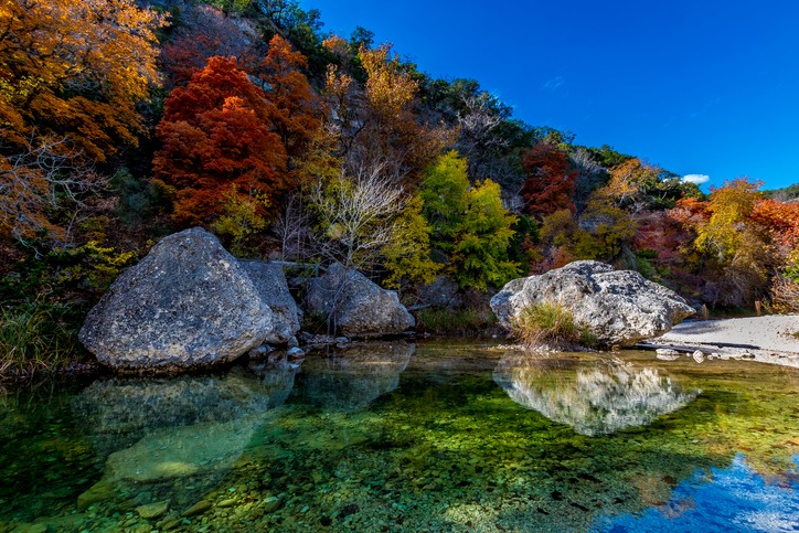

- Distance: Approximately 13 miles (multiple trails)
- Location: RR 187, 5-miles north of Vanderpool
Enchanted Rock
This lump of pink rock is technically a big mass of molten magma. The stunning panoramic views of the rock Hill Country from around 1,800 feet above the sea level is worth the effort. The day trip is suitable for backpackers of all ages and can be extended to Echo Canyon and Moss Lake. Meanwhile, here’s the list of the best online casinos we can guarantee to be safe and you can win real money.
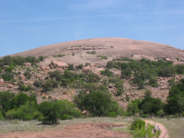
- Distance: 1.2 miles to the summit, 4 miles for loop trail
- Location: RR 965, 18-miles north of Fredericksburg
Cross Timbers Hiking Trail
This 28-mile (round trip) trail was built by the Army Corps of Engineers in 1969 along Lake Texoma’s southern shore. It begins at Juniper Point and disappears into shady limbs once you go past Cedar Bayou. Copperheads, rattlers, ticks and other biting insects are common in this area so be careful when walking through bush-covered banks.

- Distance: 28-mile round trip
- Location: US 377, 15-miles north of Whitesboro
South Rim
Located in the Big Bend National Park, the South Rim is among the most popular trails in Texas because of the stunning and unforgettable views. The hike is possible at any time of the year due to cool temperatures and shady forests. However, July and August experience thunderstorms so backpackers need to be careful during this time of the year.
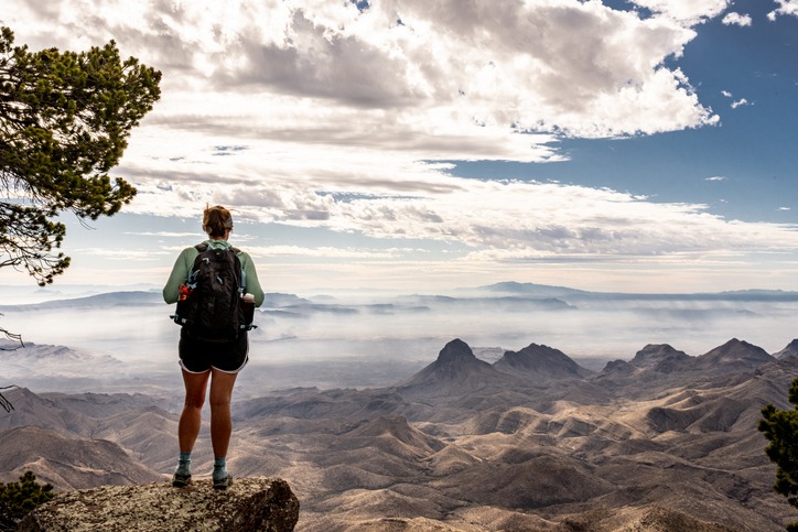
- Distance: 12-16.5 mile loop
- Location: US 385, 70-mile south of Marathon
Guadalupe Peak
At 8,749 feet, the Guadalpue Peak is the highest point in Texas and requires a climb of almost 3,000 feet. Winds reaching up to 120 miles/hour in spring and winter can blast the whole range and make it difficult for beginners to reach the peak. But once you are at the top, you experience the amazing feeling of knowing that everything is below you.
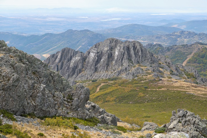
- Distance: approximately 8.5 miles
- Location: US 62/180, 110-miles east of El-Paso
Four C National Hiking Trail
This 40-mile round trip can be finished in parts and covers a variety of terrains and landscapes, including eastern forests, hardwood bottomlands, swampy quagmires and upland forest. You can explore trail’s southern end from Ratcliff after exploring the remote sections such as the Big Slough Wilderness Area. Make sure to wear bright clothing if you must hike the trail during the deer season, which lasts from 4th November to 7th January.
- Distance: 40-miles round trip, can be covered in parts
- Location: Texas Highway 7, 20-miles east of Crockett
Galveston Island
The Galveston Island State Park is a great place to visit in Texas if you want to experience diverse ecologies, including marshlands, vast dunes and briny inlets. The park is also a paradise for bird-watchers and photographers and gives you the rare chance of viewing large birds from a vantage point. Make sure to take plenty of water to stay hydrated and put some sunscreen on to protect yourself from sunlight in the open.
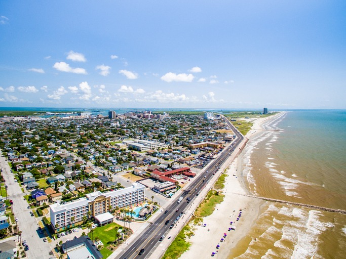

- Distance: around 4 miles (multiple trails)
- Location: FM 3005, 6-miles southwest of Galveston
Palmetto State Park
Home to more than 500 distinct plant species and over 250 bird species, an artesian well keeps the oak woodlands alive in the dry season, which is a construction project by the CCC (Civilian Conservation Corps). The thick swamps become lush green after a good rain, making it a charming spot that’s worth the time and effort. The park is also home to poisonous snakes so watch out for them and stay vigilant.
- Distance: multiple trails, 3-miles
- Location: US 183, 6-miles south of Luling
Kirby Trail
This trail provides you with an opportunity to learn about East Texas ecology, which ranges from beech slope forest, loblolly pine trees, magnolia and sloughs. The trail is a great way of experiencing raw nature, but make sure to be prepared for mosquitoes, spiders and small snakes.
- Distance: 2.5-miles (complete loop)
- Location: US 69, 7-miles north of Kountze
Lost Pines
Looping through the lovely woods of the Bastrop State Park, the Lost Pines trail passes through two forests. You can also plan on overnight hikes as primitive camping is permissible in most parts of the trail. In any case, make sure to stay on the trail otherwise you might end up getting lost in the forest.
- Distance: 8.5-miles (full loop)
- Location: Texas Highway 21, just one mile east of Bastrop
10 More Backpacking Routes in Texas
- Bush Mountain: 17-miles (round trip), US 62/180, 110-miles east of El-Paso
- Barton Creek Greenbelt: multiple trails stretching 7 miles, Spyglass Drive and Loop 360
- Cibolo Wilderness Trail: 3.5-miles, off the Texas Highway 46 in Boerne City Park
- Lake Somerville Trail-way: 26-miles round trip, begins outside Somerville
- McKinney Roughs Nature Park: long and rugged, 16-miles (multiple trails), Texas Highway 71
- Wolf Mountain Trail: 7-mile (full loop), near Dripping Springs on FM 3232
- Smith Spring: reliable water sources, 3.5-mile loop, US 62/180, 110-miles east of El-Paso
- Santa Ana National Wildlife Refuge: 12-miles (multiple trails), FM 907, 7-miles south of Alamo
- McKittrick Canyon: day use only from 8 a.m. to 6 p.m., 7-miles (round trip), US 62/180


